The Mosier to The Dalles section of the Old Highway is open to automobiles. It passes by Mosier Falls, Memaloose Overlook, Mayer State Park, Rowena Crest, and the end of the Columbia River Historic Highway, just West of The Dalles.
Mosier to The Dalles

City of Mosier (Exit 69)

Exit Interstate 84 at Mosier (Exit 69), approximately 6 miles east of Hood River. Turn left after leaving the freeway overpass, passing through the town, and head for the Historic Highway (30).
Mosier (pop. 433) was first settled in 1854 and incorporated as a city in 1914. It is 14 miles west of The Dalles and 7 miles east of Hood River, Oregon. The Tom McCall Nature Conservancy Preserve—home to more than 300 species of wildflowers—and the boat launch at the mouth of Rock Creek also draw visitors to the area.

Mosier’s white settler history dates to 1854, when Jonah H. Mosier (1821-1894) built a series of sawmills at the mouth of Mosier Creek. His son, Jefferson N. Mosier (1860-1928), platted the town and, like his father, became active in local and state affairs. During the late nineteenth century, Mosier had a railroad station and was a steamboat landing for boats headed upriver.
The sunny, rolling hills of Mosier produce great cherries including Bings, Royal Anns, Rainers and Chelans. Root Orchards in Mosier has been cherry growing since 1878. Mosier U-pick at Evans Fruit Company and organic cherries at Idiot’s Grace in Mosier are also recommended.
An oil train derailment in Mosier on June 3, 2016, highlighted the danger of shipping highly flammable materials down the Columbia Gorge, near schools and residences. More than 11 cars derailed and 4 caught fire. It sent black smoke in the air, caused evacuation of much of the town, and closed Interstate 84 for hours.
Park at the bridge over Mosier Creek and find the path signed for the Mosier Pioneer Cemetery. Mosier Creek Falls is one of the most scenic on the dry side of the Gorge. It is an easy .4 mile hike to the top of the 100-ft waterfall. This makes for a nice picnic spot with a viewing area revealing the deep canyon and pool.
Our bike map (below) shows some of the highlights of this part of the Historic Highway.

Memaloose Overlook/State Park, a few miles west of Lyle, is a good spot to view Memaloose Island. Memaloose comes from the Chinookan word “memalust” which roughly translates from “to die.” Before the dams flooded the Columbia River, there were many “memaloose” islands. All of these islands were used as burial grounds for the local Native Americans.

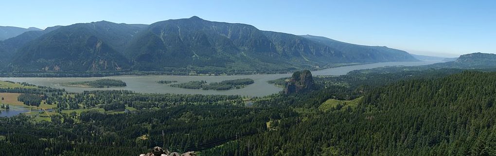
Rowena Crest is a high point on the Oregon side of the Rowena Gap, along the Historic Highway at Columbia River Mile (RM) 180.5. Rowena Crest is part of Oregon’s Mayer State Park.

Mayer State Park can be fully appreciated from the top of Rowena Crest. Swimming, boating, fishing and picnicking are available. When the spring wildflowers are in bloom, this is one of the most stunning vistas in the Columbia River Gorge.
A fast-moving wildfire raced along the scenic overlooks between Mosier and The Dalles in 2014, threatening as many as 170 homes, reports The Oregonian (video). Downstream is Tom McCall Nature Preserve. Parking at the top of the crest provides spectacular views of the Columbia River, Mayer State Park, and across to Lyle, Washington and the mouth of the Klickitat River.
Attractions near The Dalles beckon us on. Ten thousand years of Native American trading took place on the banks of the Columbia River near The Dalles, carved by the Missoula Floods.