Welcome
Welcome virtual travelers! The historic Columbia River Highway, the first scenic highway in the United States, celebrates its 100th anniversary in 2015.

Take this journey with us. We’ve collected dozens of vintage audio and video clips as well as the latest Photospheres (similar to Streetview), that capture 360 degree (Virtual Reality) views throughout The Gorge. We added some Woodie Guthrie and ambient sounds from Archive.org to the mix. The Woody Guthrie Centennial has more.
BULLETIN: Here’s a 30 page situation report on the Eagle Creek Fire (09/05/17) which is threatening the Gorge, the Bullrun Watershed and many things Oregonians hold dear.
Since internet connectivity is poor along much of the Gorge Highway download a pdf of this site here (12MB)
About The Gorge
The Columbia River Highway opened on July 6, 1915, with an unpaved section between Portland and Hood River. It would take nearly year to pave the route and complete the finishing touches. On June 7, 1916, a ceremony at Multnomah Falls celebrated its completion. Vista House was dedicated in 1918. From 1916 to 1920 highway construction proceeded in sections east from Hood River to The Dalles.
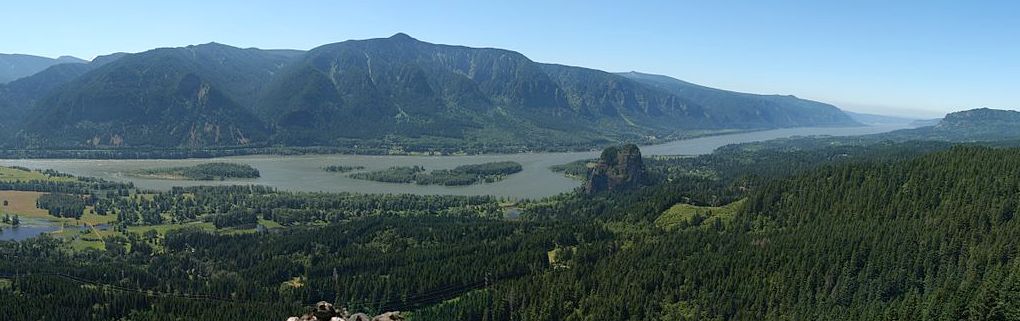
This historic road serpentines along the cliffs and waterfalls through the Columbia River Gorge in a spectacular 80 mile journey from Troutdale (near Portland) to The Dalles along the Columbia River.
The highway’s engineer, Sam Lancaster, did “not want to mar what God had put there,” and worked diligently to showcase the many waterfalls and “beauty spots” on the highway. The River They Saw chronicles the early Gorge in photos.
The Historic Columbia River Highway Advisory Committee and the Friends of the Historic Columbia River Highway hope to reconnect the missing sections of the Historic Highway, creating a continuous roadway through the Gorge, without having to travel along parts of Interstate 84, between Portland and The Dalles.
Milepost 2016 identifies areas that need to be finished to allow total reconnection of the Historic Highway, although some sections (the State Trail) will remain limited to bikers and hikers. Of the original 73 miles of historic highway, one can currently access about 61 miles either by car on the drivable portions or by foot or bike on the State Trail sections, with about 12 miles remaining unconnected.
The Columbia Gorge Express bus is a convenient way to get from Portland to Multnomah Falls. Round trip from the Gateway Transit Center is only $5.
Immersive Sightseeing
This website provides panoramic images along the Gorge highway, historical anecdotes and current information. You can also view the 360 degree images using Virtual Reality headsets like Google Cardboard, a $20 viewer that, when coupled with a smartphone, provides an immersive experience with side-by-side stereo rendering. Google also has Cardboard support for IOS in YouTube, while the cardboard viewer costs around $12.
Download the latest Google Streetview for Android and for IOS to enable viewing 360 degree Photospheres via Google Cardboard.
UPDATE: My intent was to embed my original 360 photos on this site, but I wasn’t happy with my own photos so I’ve just embedded 360 views from Google and other sources. In the end, this site is less than I hoped for, but it is what it is. I hope it can be useful.

I hope to add my own photosphere pictures of the Gorge in the future. Meanwhile 360 Labs has a terrific selection of 360 stills and videos of the region.

A Portland to Hood River Bike Map shows some of that journey is restricted to hiking and biking only.

The Historic Columbia River Highway provides some of the most spectacular vistas in the Northwest. Let’s go!
– Sam Churchill, January 2015